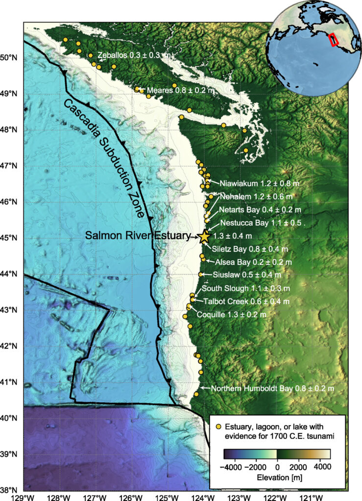
Cascadia subduction zone showing the location of the Salmon River estuary (yellow star) and other onshore areas with identified tsunami deposits from the 1700 CE earthquake (yellow dots). Credit: Journal of Geophysical Research: Earth’s Surface (2024). DOI: 10.1029/2023JF007444
x CLOSED
Cascadia subduction zone showing the location of the Salmon River estuary (yellow star) and other onshore areas with identified tsunami deposits from the 1700 CE earthquake (yellow dots). Credit: Journal of Geophysical Research: Earth’s Surface (2024). DOI: 10.1029/2023JF007444
To better understand the scale of past earthquakes and tsunamis, scientists often use earthquake modeling or turn to evidence that tsunamis leave behind, such as sand deposits.
The most recent large earthquake in the Cascadia Subduction Zone, which spans the Pacific Northwest coast, is the focus of much study because geological evidence of the event is found from Northern California to Vancouver Island, and observations of the accompanying tsunami were even recorded in Japan. . These observations, combined with computer modeling, have allowed researchers to estimate the earthquake that occurred at 21:00 on January 26, 1700.
Numerous studies have collected sediment cores to estimate how much subsidence the earthquake caused in coastal wetlands. Studies modeling the 1700 earthquake rely on these slip estimates to predict how much the fault slipped. Other studies focus on the extent and thickness of the layers of sand and silt washed inland by the tsunami. But no study in Cascadia has yet combined mapping the full extent of these sand tsunami deposits with a sediment transport model to determine earthquake magnitude.
SeanPaul La Selle and colleagues took 129 cores from marshes at the mouth of the Salmon River along the northern Oregon coast and combined them with 114 existing core logs to test how well different models of the 1700 Cascadia earthquake performed.
Scientists, including SeanPaul La Selle (left) and Jason Padgett (right), are using cores to map the inner boundary of deposits from a tsunami off the Oregon coast around 1700. Then, they simulate earthquakes and tsunamis that could recreate the deposits. Credit: Alan Nelson, USGS
x CLOSED
Scientists, including SeanPaul La Selle (left) and Jason Padgett (right), are using cores to map the inner boundary of deposits from a tsunami off the Oregon coast around 1700. Then, they simulate earthquakes and tsunamis that could recreate the deposits. Credit: Alan Nelson, USGS
Using the hydrodynamic and sediment transport model Delft3D-FLOW, the authors tested 15 different earthquake models to see how well each reproduced the distribution of sediments brought inland by the tsunami.
They found that to match the thickness and extent of the tsunami sediments found in the cores, the earthquake would likely have caused at least 0.8 meters of sliding on the Salmon River and about 12 meters of sliding on the fault. Seven of the earthquake models they tested reproduced these conditions at low tide (when the main Cascadia earthquake occurred).
The findings are published in Journal of Geophysical Research: Earth’s Surface.
The study provides new constraints on the magnitude and character of the 1700 Cascadia earthquake. It also provides new insights into how models of tsunami deposit mapping and sediment transport can be used to better reproduce past earthquakes and tsunamis. related to them – and to provide insight into future events.
The authors note that their models were more sensitive to tidal level, sand grain size, and sediment transport coefficients, knowledge that may help further constrain future models of this and other earthquakes. Further work involving collecting more tsunami deposit data, testing a wider set of earthquake sources, and comparing sediment transport and hydrodynamic models may reveal more details.
More information:
SeanPaul M. La Selle et al, Testing Megathrust Rupture Models Using Tsunami Deposits, Journal of Geophysical Research: Earth’s Surface (2024). DOI: 10.1029/2023JF007444
This story is reprinted courtesy of Eos, hosted by the American Geophysical Union. Read the original story here.